Property Record
1698 Route 209 Rd, Stroudsburg, PA 18360
NEARBY LISTINGS FOR SALE OR LEASE
-
-
View all Stroudsburg listings for sale on LoopNet.com
Property Detail
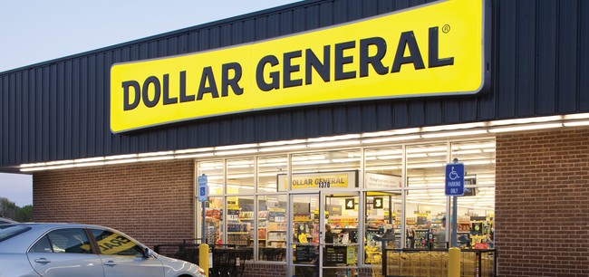
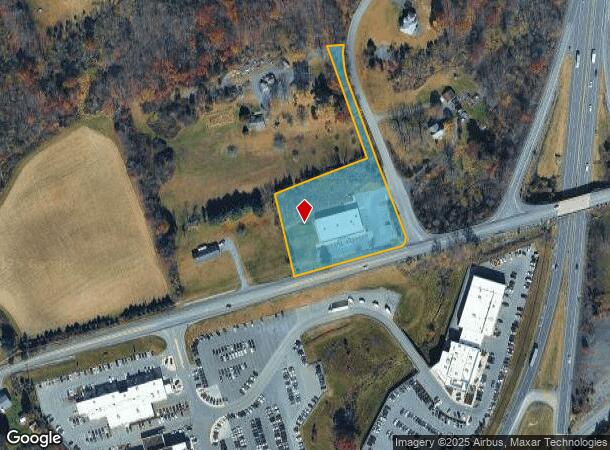
1698 Route 209 Rd
07.6.1.40-3
East View Est Sec Iv
Wholesaleoutletdiscountstore
INC SM PT OF HWY
X
Monroe
42089C0407E
Pennsylvania
2025
2.38 AC
2025
Monroe County
301101
Philadelphia
9,177 SF
East Stroudsburg, PA
DEMOGRAPHICS near 1698 Route 209 Rd
1 Mile
3 Mile
5 Mile
2024 Total Population
916
8,229
27,533
2029 Population
887
8,129
27,339
Pop Growth 2024-2029
(3.17%)
(1.22%)
(0.70%)
Average Age
45
45
44
2024 Total Households
338
3,138
10,719
HH Growth 2024-2029
(3.25%)
(0.80%)
(0.54%)
Median Household Inc
$65,833
$70,008
$73,575
Avg Household Size
2.50
2.50
2.50
2024 Avg HH Vehicles
2.00
2.00
2.00
Median Home Value
$265,941
$261,623
$255,374
Median Year Built
1982
1983
1981
Nearby Places
- Restaurants
- Banks
- Shops
- Fitness
- Groceries
PUBLIC TRANSPORTATION
AIRPORT
Lehigh Valley International
DRIVE
WALK
Distance
Lehigh Valley International
42 min
27.4 mi
Freight Ports
Maher Terminal
DRIVE
WALK
Distance
Maher Terminal
97 min
75.9 mi
SALE & LEASE HISTORY
LISTING DATE
SALE/LEASE

Nov 07, 2018
For Sale
Nearby Properties
Address
Land Use
TOTAL SIZE
Lot Size
Zoning
Address
Land Use
TOTAL SIZE
Lot Size
Zoning
382,084 SF
43.31 AC
C-2
Address
Land Use
TOTAL SIZE
Lot Size
Zoning
85,940 SF
16.19 AC
C-2
Address
Land Use
TOTAL SIZE
Lot Size
Zoning
39,779 SF
27.15 AC
C
Address
Land Use
TOTAL SIZE
Lot Size
Zoning
2,632 SF
73.18 AC
A
Address
Land Use
TOTAL SIZE
Lot Size
Zoning
70,939 SF
2.33 AC
C-2
Address
Land Use
TOTAL SIZE
Lot Size
Zoning
13,050 SF
5.96 AC
C-2
Address
Land Use
TOTAL SIZE
Lot Size
Zoning
49,848 SF
5.15 AC
C-2
Address
Land Use
TOTAL SIZE
Lot Size
Zoning
468,747 SF
Address
Land Use
TOTAL SIZE
Lot Size
Zoning
89,411 SF
9 AC
C1
Address
Land Use
TOTAL SIZE
Lot Size
Zoning
63,576 SF
12.56 AC
A
Address
Land Use
TOTAL SIZE
Lot Size
Zoning
39,879 SF
2.91 AC
C-2
Address
Land Use
TOTAL SIZE
Lot Size
Zoning
8,554 SF
194 AC
C-3
Address
Land Use
TOTAL SIZE
Lot Size
Zoning
39,635 SF
4.78 AC
C-2
Address
Land Use
TOTAL SIZE
Lot Size
Zoning
32,166 SF
3.16 AC
C-2
Address
Land Use
TOTAL SIZE
Lot Size
Zoning
10,988 SF
10 AC
R1
Address
Land Use
TOTAL SIZE
Lot Size
Zoning
49,255 SF
2.89 AC
C-2
Address
Land Use
TOTAL SIZE
Lot Size
Zoning
27,360 SF
4.52 AC
C-2
Address
Land Use
TOTAL SIZE
Lot Size
Zoning
19,118 SF
5.30 AC
C-2
Address
Land Use
TOTAL SIZE
Lot Size
Zoning
18,330 SF
16.70 AC
C
Address
Land Use
TOTAL SIZE
Lot Size
Zoning
55,588 SF
12.16 AC
C-2
Address
Land Use
TOTAL SIZE
Lot Size
Zoning
4,844 SF
5.38 AC
C-2
Address
Land Use
TOTAL SIZE
Lot Size
Zoning
3,516 SF
24.60 AC
C-2
Address
Land Use
TOTAL SIZE
Lot Size
Zoning
21,500 SF
2.99 AC
C-2
Address
Land Use
TOTAL SIZE
Lot Size
Zoning
30,924 SF
2.41 AC
A
Address
Land Use
TOTAL SIZE
Lot Size
Zoning
7,425 SF
4.62 AC
A
Address
Land Use
TOTAL SIZE
Lot Size
Zoning
30,467 SF
10.43 AC
A
Address
Land Use
TOTAL SIZE
Lot Size
Zoning
1,000.70 AC
CV
Address
Land Use
TOTAL SIZE
Lot Size
Zoning
17,294 SF
4.40 AC
R-3
Address
Land Use
TOTAL SIZE
Lot Size
Zoning
6,587 SF
2.74 AC
C
Address
Land Use
TOTAL SIZE
Lot Size
Zoning
2,751 SF
0.72 AC
C-2
The World's #1 Commercial Real Estate Marketplace
Connect with us
© 2025 CoStar Group
The information above has been obtained from sources believed reliable. While we do not doubt its accuracy we have not verified it and make no guarantee, warranty or representation about it. It is your responsibility to independently confirm its accuracy and completeness. Any projections, opinions, assumptions, or estimates used are for example only and do not represent the current or future performance of the property. The value of this transaction to you depends on tax and other factors which should be evaluated by your tax, financial, and legal advisors. You and your advisors should conduct a careful, independent investigation of the property to determine to your satisfaction the suitability of the property for your needs.